There are three main parts of the 5-digit ZIP Code—the national area, the region or city, and the delivery area.The United States Postal Service (USPS) has segmented the country into 10 ZIP Code areas. Starting in the northeast, they are numbered 0-9
The first digit of zipcode allotted as follows:
| ZIP Codes Beginning With | States |
| 0 | Connecticut (CT), Massachusetts (MA), Maine (ME), New Hampshire (NH), New Jersey (NJ), New York (NY, Fishers Island only), Puerto Rico (PR), Rhode Island (RI), Vermont (VT), Virgin Islands (VI), Army Post Office Europe, Central Asia, and the Middle East (APO AE); Fleet Post Office Europe and the Middle East (FPO AE) |
| 1 | Delaware (DE), New York (NY), Pennsylvania (PA) |
| 2 | Alabama (AL), Florida (FL), Georgia (GA), Mississippi (MS), Tennessee (TN), Army Post Office Americas (APO AA), Fleet Post Office Americas (FPO AA) |
| 3 | District of Columbia (DC), Maryland (MD), North Carolina (NC), South Carolina (SC), Virginia (VA), West Virginia (WV) |
| 4 | Indiana (IN), Kentucky (KY), Michigan (MI), Ohio (OH) |
| 5 | Iowa (IA), Minnesota (MN), Montana (MT), North Dakota (ND), South Dakota (SD), Wisconsin (WI) |
| 6 | Illinois (IL), Kansas (KS), Missouri (MO), Nebraska (NE) |
| 7 | Arkansas (AR), Louisiana (LA), Oklahoma (OK), Texas (TX) |
| 8 | Arizona (AZ), Colorado (CO), Idaho (ID), New Mexico (NM), Nevada (NV), Utah (UT), Wyoming (WY) |
| 9 | Alaska (AK), American Samoa (AS), California (CA), Guam (GU), Hawaii (HI), Marshall Islands (MH), Federated States of Micronesia (FM), Northern Mariana Islands (MP), Oregon (OR), Palau (PW), Washington (WA), Army Post Office Pacific (APO AP), Fleet Post Office Pacific (FPO AP) |
Zipcode structure
5-digit ZIP Code contains 3 parts.
- national area
- the region or city
- associated Post office delivery area
for example, the zipcode 10580 denotes,
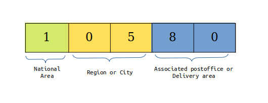
ZIP Codes are numbered with the first digit representing a certain group of U.S. states, the second and third digits together representing a region in that group (or perhaps a large city) and the fourth and fifth digits representing a group of delivery addresses within that region. The main town in a region (if applicable) often gets the first ZIP Codes for that region; afterward, the numerical order often follows the alphabetical order. Because ZIP Codes are intended for efficient postal delivery.
The first three digits of a ZIP Code together usually indicate the sectional center facility to which that ZIP Code belongs. This facility is the mail sorting and distribution center for a zone or area. Some sectional center facilities have multiple three-digit codes assigned to them.
The fourth and fifth digits of the ZIP Code represent the area of the city or town. For example, if a letter is received with a ZIP Code of 10580, the USPS can know that it's in Newyork (1), it's in Westchester county (05), and it's in the area of the Rye (80).
Zipcodes boundary
A ZIP Code's address and the city name written on the same line do not necessarily mean that address is within the boundaries of that city. ZIP Codes are not drawn according to state boundaries. In fact, since they are designed only to increase mailing efficiency, ZIP Codes can and do cross county and state boundaries.
Although most ZIP Codes can be roughly assigned to a geographic area, ZIP Codes do not represent geographic regions; ZIP Codes denote address groups or delivery routes. Because of this, ZIP Code "areas" can overlap, be contained within another ZIP Code, or have no geographic area. For example ZIP Codes that start with 095 are assigned to the Navy, and therefore have no geographic location. Similarly, areas without regular postal routes (rural route areas) or areas with no mail delivery (undeveloped areas), are not assigned ZIP Codes. They are based on sparse delivery routes, so the boundary between ZIP Code areas there is indefinite.
ZIP+4 Codes
In 1983, the USPS changed its ZIP Code system to include the new ZIP+4. A ZIP+4 Code uses the basic five-digit code plus four additional digits to identify a small delivery segment such as a street, a city block, a group of apartments, or even an individual address that receives a high volume of mail. The ZIP+4 Code is not required and is usually calculated automatically when the mail is sorted and processed.
As a rule, each Post Office Box has it's own ZIP+4 Code. The +4 on the ZIP Code is often the last four digits of the box number, zero plus the last three digits of the box number, or, if the box number is less than 4 digits, zeros followed by the box number. Since there is this variance, the ZIP+4 Code must be looked up individually for each Post Office Box.
Please note that, Not all USPS deliverable addresses have a ZIP+4 Code assigned to them. For those addresses, geocoding lookups or address validation that require a ZIP+4 may not succeed.